- Home Page /
- Electronics /
- Car & Vehicle Electronics /
- Marine Electronics /
- Marine GPS Accessories /
- C-MAP Reveal Coastal - Gulf of Mexico and The...
0 ratings

Item #:
220511577
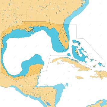
C-MAP Reveal Coastal - Gulf of Mexico and The Bahamas, Map Card for Marine GPS Navigation
Item #:
220511577
XCD 1095
Price Details
Excluding Shipping & Custom charges ( Shipping and custom charges will be calculated on checkout )
*All items will import from US
0 ratings
Write a review
In stock
QTY:
Order now and get it around Wednesday, July 08
Secured transaction
Ubuy works hard to protect your security and privacy. Our advanced payment security system ensures confidentiality by encrypting your information during transmission using AES (Advanced Encryption Standards) and SSL (Secure Socket Layer) protocols. Your payment details are 100% secure as we do not share your payment details with third party sellers.
Our Top Logistics Partners
Fast
Shipping
Free
Return*
Secure Packaging
100% Original Products
PCI DSS Compliance

ISO 27001 Certified
Note: Step Down Voltage Transformer required for using electronics products of US store (110-120). Recommended power converters Buy Now.


What Stands Out
Comprehensive Coverage
Offers extensive cartography of South Central US lakes, providing users with precise navigation details. Ideal for anglers and recreational boaters seeking reliable, detailed maps of their favorite waterways.
User-Friendly Interface
Designed for seamless integration with marine GPS systems, ensuring easy access to vital navigation data. Intuitive layout enhances user experience, making it suitable for all skill levels.
Updated Data
Regularly refreshed map data ensures users have the latest information on lake conditions and features, allowing for safer and more enjoyable outings on the water compared to static competitors.
Product Details
- C-MAP Reveal Coastal Charts for Marine GPS Navigation
- Features shaded relief for 3D rendered land and underwater elevation
- Includes Ultra-High-Res Bathymetric imagery for anglers and divers
- Accurate and up-to-date vector chart detail derived from official Hydrographic Office information
- Identify shallow areas, drop-offs, ledges, holes or humps with high-res bathymetry
- Customize depth shading for clear safety settings or personal preferences
| Item Weight | 0.5 lbs (230 grams) |
Product Description
C-MAP Reveal Coastal - Gulf of Mexico and The Bahamas, Map Card for Marine GPS Navigation
Have any Query? Chat with us
Customer Questions & Answers
-
Question:
What features do C-MAP Reveal Coastal Charts offer for marine navigation?
Answer: C-MAP Reveal Coastal Charts provide advanced features such as shaded relief, high-resolution bathymetry, and vector support. These features are crucial for mariners as they enhance navigational accuracy and safety. Shaded relief visualizes underwater terrain, while hi-res bathymetry details the depths and contours of the seabed. The vector data further enriches maps by providing precise navigational aids, reducing the risk of grounding or accidents, especially in unfamiliar waters. -
Question:
How do I install C-MAP Reveal Coastal Charts on my marine GPS device?
Answer: To install C-MAP Reveal Coastal Charts, you’ll first need to ensure your GPS device is compatible. Most marine GPS units allow map updates via a microSD card or direct download. Once you have the charts, insert the card into the device, navigate to the settings, and follow the prompts for map installation. Proper installation enables you to utilize all the detailed charts during your nautical adventures, providing confidence and precision on the water. -
Question:
Can I use C-MAP Reveal Coastal Charts for fishing?
Answer: Yes, C-MAP Reveal Coastal Charts are particularly beneficial for fishing. The charts include detailed bathymetric data that reveals underwater features such as drop-offs, reefs, and channel markers, which are attractive to fish. By leveraging the custom depth shading feature, anglers can identify prime fishing spots with ease. This level of detail enhances your chances of a successful catch on your fishing expeditions. -
Question:
Are C-MAP Reveal Coastal Charts suitable for recreational boating?
Answer: Absolutely! C-MAP Reveal Coastal Charts are designed for a variety of applications, including recreational boating. The high-resolution visuals and detailed terrain mapping make them ideal for planning routes and avoiding hazards. Whether you’re sailing on a calm lake or navigating coastal waters, these charts provide the critical information you need for safe and enjoyable boating experiences. -
Question:
What types of vessels benefit the most from using C-MAP Reveal Coastal Charts?
Answer: C-MAP Reveal Coastal Charts benefit a wide range of vessels, including yachts, fishing boats, and commercial vessels. Their detailed bathymetry allows for safer navigation in shallow or complex waters. Additionally, recreational boaters and navigators can utilize these charts to ensure awareness of maritime traffic, environmental hazards, and local regulations, thus enhancing overall voyage safety. -
Question:
What is the importance of the shaded relief feature in C-MAP Reveal Coastal Charts?
Answer: The shaded relief feature enhances visual interpretation of the underwater landscape, providing a three-dimensional perspective. This feature is crucial for identifying potential navigation hazards such as submerged rocks and reefs. By using shaded relief, mariners can make informed decisions about their routes, avoiding risks and improving safety during navigation, especially in areas where depth variations are significant. -
Question:
Can I access C-MAP Reveal Coastal Charts on multiple devices?
Answer: Yes, C-MAP Reveal Coastal Charts can typically be accessed on multiple devices as long as they are registered under the same account. Some systems allow you to sync your purchased maps across tablets, smartphones, and compatible marine GPS units. This flexibility allows for seamless planning and navigational adjustments, whether onshore or on the water. -
Question:
How frequently are C-MAP Reveal Coastal Charts updated?
Answer: C-MAP Reveal Coastal Charts are regularly updated to incorporate new data such as changes in navigational aids, underwater features, and coastal developments. This commitment to accuracy ensures that mariners have access to the latest information. Keeping charts updated enhances navigational safety, as it helps avoid outdated information that could lead to critical errors on the water. -
Question:
What role do vectors play in C-MAP Reveal Coastal Charts?
Answer: Vectors in C-MAP Reveal Coastal Charts offer detailed vector graphics that include navigational aids like buoys, lights, and shoreline boundaries. This layer of data enhances the charts’ functionality by providing real-time updates and precise locations of these aids. Vectors are crucial for safe navigation, as they help mariners ensure compliance with navigational rules and identify exact positions on their routes. -
Question:
Where can I buy C-MAP Reveal Coastal Charts for Marine GPS Navigation in Saint Lucia?
Answer: You can conveniently buy C-MAP Reveal Coastal Charts for Marine GPS Navigation with Shaded Relief, Hi-Res Bathymetry, Vectors, and Custom Depth Shading from Ubuy. They offer a straightforward purchasing process and a reliable selection of marine navigation products, ensuring you have access to these detailed charts for enhanced maritime safety.
C-MAP Marine GPS Accessories Editorial Review
No editorial reviews found
Customer Reviews & Ratings
1 customers ratings
-
5 Star
100%
-
4 Star
0%
-
3 Star
0%
-
2 Star
0%
-
1 Star
0%
Review this product
Share your thoughts with other customers
Product Price History
Important information
- Limitations : For products shipped internationally, please note that any manufacturer warranty may not be valid; manufacturer service options may not be available; product manuals, instructions, and safety warnings may not be in destination country languages; the products (and accompanying materials) may not be designed in accordance with destination country standards, specifications, and labeling requirements; and the products may not conform to destination country voltage and other electrical standards (requiring use of an adapter or converter if appropriate). The recipient is responsible for assuring that the product can be lawfully imported to the destination country. When ordering from Ubuy or its affiliates, the recipient is the importer of record and must comply with all laws and regulations of the destination country.
- Not all the products listed on Ubuy are for sale, as Ubuy is a global search engine. Products are subject to export/trade regulations.
XCD 1095
Order now and get it around Wednesday, July 08
This item is not restrict in my country.(Please click on above link if this item is not restrict in your country, So our team will review and allow.)
QTY:
Secured transaction
Ubuy works hard to protect your security and privacy. Our advanced payment security system ensures confidentiality by encrypting your information during transmission using AES (Advanced Encryption Standards) and SSL (Secure Socket Layer) protocols. Your payment details are 100% secure as we do not share your payment details with third party sellers.
Our Top Logistics Partners
Fastest cross-border delivery