- Home Page /
- Electronics /
- Car & Vehicle Electronics /
- Marine Electronics /
- Marine GPS Chartplotters /
- Navionics Garmin 010-C1370-40 U.S. East Plati...
0 ratings

Item #:
94325332
Navionics Garmin 010-C1370-40 U.S. East Platinum+ microSD/SD Card NPUS007R, Black
Item #:
94325332
XCD 469
Price Details
Excluding Shipping & Custom charges ( Shipping and custom charges will be calculated on checkout )
*All items will import from US
0 ratings
Write a review
In stock
 Imported from USA store
QTY:
Order now and get it around Tuesday, August 18
Secured transaction
Ubuy works hard to protect your security and privacy. Our advanced payment security system ensures confidentiality by encrypting your information during transmission using AES (Advanced Encryption Standards) and SSL (Secure Socket Layer) protocols. Your payment details are 100% secure as we do not share your payment details with third party sellers.
Our Top Logistics Partners


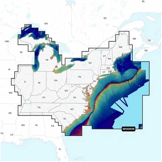
Navigate with our best offshore and inland lake coverage for your Garmin chartplotter.

Fast
Shipping

Free
Return*

Secure Packaging

100% Original Products

PCI DSS Compliance

ISO 27001 Certified


Note: Step Down Voltage Transformer required for using electronics products of US store (110-120). Recommended power converters Buy Now.


What Stands Out
Comprehensive Coverage
Offers detailed marine and lake maps for the entire U.S. East Coast, ensuring navigators have access to extensive coverage for safe and informed boating experiences.
Advanced Chart Technology
Utilizes high-resolution, sonar-enhanced charts that provide real-time updates and customization, giving users superior navigation accuracy and an edge over standard navigation solutions.
User-Friendly Interface
Designed for seamless integration with Garmin devices, this microSD/SD card allows for easy-to-navigate maps, enhancing the user experience for both novice and seasoned boaters.
Product Details
| Compatible with Vehicle Type | Boat |
| Screen Size | 25 |
| Additional Features | 3D View, Aerial Photos, Dock-to-dock Route Guidance, Relief Shading, Satellite Imagery with SonarChart Shading Overlay, Sonar Imagery, SonarChart Live Mapping Feature |
| Connectivity Technology | USB |
| Map Types | North America |
| Mounting Type | Dashboard Mount, Panel Mount |
| Operating System | Proprietary (Garmin Os) |
| Memory Storage Capacity | 4 GB |
| Touch Screen Type | Capacitive |
| Display Type | LCD |
| Human-Interface Input | Buttons |
| Compatible Devices | Garmin Chartplotters |
| Control Method | App |
| Are Batteries Included | No |
| Supported Satellite Navigation System | GPS |
| Compatible Flash Memory Type | SD, microSD |
| Sport Type | Fishing |
| Brand | Navionics |
| Model Name | NPUS007R - U.S. East |
| Built-In Media | Navionics Garmin 010-C1370-40 U.S. East Platinum+ microSD/SD Card NPUS007R, Black |
| UPC | 821245991775 |
| Manufacturer | Garmin |
| Model Number | 010-C1370-40 |
| Mfr Part Number | 010-C1370-40 |
| Item Type Name | Navionics Garmin 010-C1370-40 U.S. East Platinum+ microSD/SD Card NPUS007R, Black |
| Unit Count | 1.0 Count |
| Vehicle Service Type | Boat |
| Special Feature | 3D View, Aerial Photos, Dock-to-dock Route Guidance, Relief Shading, Satellite Imagery with SonarChart Shading Overlay, Sonar Imagery, SonarChart Live Mapping Feature See more |
| Map Type | North America |
| Included Components | Navionics Garmin 010-C1370-40 U.S. East Platinum+ microSD/SD Card NPUS007R, Black |
| Item Weight | 0.1 lbs (50 grams) |
Who Should Buy?

-
Boating Enthusiasts
Ideal for sailors and motorboat users seeking detailed charts for navigating U.S. East waters.
-
Fishermen
Perfect for anglers who require accurate depth and fishing spot information in coastal and inland waters.
-
Maritime Professionals
Essential for maritime operators needing high-resolution maps and data for commercial navigation and planning.

-
Hikers and Cyclists
Not useful for land-based activities as it's specifically designed for marine navigation and not terrestrial guidance.
Product Description
Navionics Garmin 010-C1370-40 U.S. East Platinum+ microSD/SD Card NPUS007R, Black
Have any Query? Chat with us
Customer Questions & Answers
-
Question:
What features does the Navionics Garmin 010-C1370-40 U.S. East Platinum microSDSD card offer?
Answer: The Navionics Garmin 010-C1370-40 U.S. East Platinum microSDSD card comes equipped with detailed nautical charts, essential for safe navigation. It features comprehensive coverage of the U.S. East Coast, including inland lakes and waterways, enhancing your boating experience. This card supports advanced features like SonarChart™ Live and Community Edits, allowing for the most up-to-date navigation data. Whether you are a recreational boater or a serious angler, having this information at your fingertips can significantly improve your trip planning and safety on the water. -
Question:
Is the Navionics Garmin 010-C1370-40 compatible with all Garmin chartplotters?
Answer: The Navionics Garmin 010-C1370-40 is specifically designed for compatibility with a range of Garmin chartplotters. It's compatible with many of the recent models, ensuring that you can leverage its high-definition charts and features. However, it’s always a good idea to check the Garmin compatibility list for your specific device model to ensure seamless integration. Upgrading your chartplotter with this microSD card can greatly enhance your navigation experience and improve your on-water decision-making. -
Question:
Can I update the Navionics Garmin 010-C1370-40 card?
Answer: Yes, the Navionics Garmin 010-C1370-40 card can be updated regularly to reflect the latest changes in water charts and features. Users can access the Navionics Updates service, which provides opportunities for chart updates when conditions in the marine environment change. This is particularly useful for users navigating frequently changing waters or exploring new routes. By keeping your card updated, you ensure that you have the most precise and relevant navigation data available. -
Question:
What is SonarChart™ Live and how does it work with the Navionics Garmin 010-C1370-40?
Answer: SonarChart™ Live is an innovative feature that allows anglers to create real-time, customized bathymetric maps directly on their Garmin devices using the Navionics Garmin 010-C1370-40 card. This feature enables users to record their sonar logs while out on the water, which are then processed to produce high-resolution maps that highlight both depth and bottom composition. This is perfect for those looking to discover new fishing spots or gain insight into specific areas in situ. Utilizing this feature can elevate your fishing strategy and improve your overall success rate. -
Question:
What areas are covered by the Navionics Garmin 010-C1370-40 U.S. East Platinum?
Answer: The Navionics Garmin 010-C1370-40 U.S. East Platinum provides extensive coverage of the U.S. East Coast, including popular areas such as the Great Lakes, Chesapeake Bay, and coastal waters. The detailed inland maps are also included, making it a valuable tool for both coastal and freshwater navigation. This wide coverage ensures that whether you are an offshore sailor, a weekend boater, or interested in fishing on smaller lakes and rivers, you have comprehensive navigational support wherever you go. -
Question:
How do community edits enhance the usability of the Navionics Garmin 010-C1370-40 card?
Answer: Community Edits allow users to contribute local knowledge and data, which enhances the information available on the Navionics Garmin 010-C1370-40 card. By utilizing data shared by other users, such as updated depths, hazards, and points of interest, you can benefit from a more dynamic and accurate representation of the waterways. This collaborative feature is particularly beneficial for users venturing into less charted areas where local knowledge can lead to safer and more productive trips. -
Question:
Can the Navionics Garmin 010-C1370-40 card be used for freshwater navigation?
Answer: Absolutely! The Navionics Garmin 010-C1370-40 card includes coverage for various freshwater lakes and rivers along the U.S. East Coast. This feature makes it an excellent choice for anglers and recreational boaters who frequently navigate both salt and freshwater environments. By providing detailed charts for these areas, the card enables users to experience a seamless transition between different types of waterways, ensuring safe and efficient navigation no matter where you choose to explore. -
Question:
How does the Navionics app work with the Garmin 010-C1370-40 card?
Answer: The Navionics app complements the functionality of the Garmin 010-C1370-40 card by allowing users to access nautical charts and features on their smartphones or tablets. This integration means you can view and plan your routes on the app, and then use the card for real-time navigation on your dedicated Garmin device. The app also allows for syncing updates and managing waypoints between devices, making it an invaluable tool for on-the-water preparations and follow-up reviews of your trips. -
Question:
What should I do if my Navionics Garmin 010-C1370-40 card is not recognized by my chartplotter?
Answer: If your Navionics Garmin 010-C1370-40 card is not recognized by your chartplotter, first ensure that the card is fully inserted correctly and that your chartplotter's firmware is updated. Sometimes, card compatibility issues can arise from outdated software. If the problem persists, trying the card in another compatible device can help determine if the issue is with the card or the original plotter. Additionally, checking the manufacturer’s support guide for troubleshooting steps and compatibility issues can provide further assistance. -
Question:
Where can I buy the Navionics Garmin 010-C1370-40 U.S. East Platinum microSDSD card?
Answer: You can buy the Navionics Garmin 010-C1370-40 U.S. East Platinum microSDSD card from Ubuy. This platform offers a wide selection of electronic navigation products and is known for reliable service. By purchasing through Ubuy, you ensure you have access to customer support and detailed product descriptions, which can enhance your shopping experience. Whether you are a seasoned boater or a novice, Ubuy is a great option for acquiring essential navigation cards like this one.
Navionics Marine GPS Chartplotters 010-C1370-40 Editorial Review
No editorial reviews found
Customer Reviews & Ratings
1 customers ratings
-
5 Star
100%
-
4 Star
0%
-
3 Star
0%
-
2 Star
0%
-
1 Star
0%
Review this product
Share your thoughts with other customers
Platform Trust & Buyer Confidence

MA
Mohammad
Verified buyer
“Excellent quality and original too,when ubuy send original things I will appreciate that ,I very satisfied thank you”
23 July 2026 · via Trustpilot
CK
Chitra
Verified buyer
“The order and delivery progress was communicated very well. Package arrived within the estimated time. Products arrived as expected in good condition.”
22-Jul-26 · via Trustpilot
K
kund
Verified buyer
“Good supply of products. Safe payment methods, and shipment worldwide! Genuine products.”
23-Jul-26 · via Trustpilot
OO
Onesi
Verified buyer
“Was my first time buying a product from Ubuy, but I found it so helpful. This is reliable. Gonna place a new order!”
22 July 2026 · via Trustpilot
SJ
SAO JOHN
Verified buyer
“Ubuy is a great online platform to buy stuff. Reliable, fast delivery time and great value for money. I've been using Ubuy online shopping platform for three years now and will continue to do so.”
23 July 2026 · via Trustpilot
Secure Checkout
Global Delivery
Easy Returns
Genuine Products
Product Price History
Important information
- Limitations : For products shipped internationally, please note that any manufacturer warranty may not be valid; manufacturer service options may not be available; product manuals, instructions, and safety warnings may not be in destination country languages; the products (and accompanying materials) may not be designed in accordance with destination country standards, specifications, and labeling requirements; and the products may not conform to destination country voltage and other electrical standards (requiring use of an adapter or converter if appropriate). The recipient is responsible for assuring that the product can be lawfully imported to the destination country. When ordering from Ubuy or its affiliates, the recipient is the importer of record and must comply with all laws and regulations of the destination country.
- Not all the products listed on Ubuy are for sale, as Ubuy is a global search engine. Products are subject to export/trade regulations.
XCD 469
Order now and get it around Tuesday, August 18
This item is not restrict in my country.(Please click on above link if this item is not restrict in your country, So our team will review and allow.)
QTY:
Secured transaction
PCI DSS compliant and ISO 27001:2022 certified, with encrypted payments and full buyer protection on every order.
Our Top Logistics Partners
Fastest cross-border delivery
Features & Benefits
- Best offshore and inland lake coverage for Garmin chartplotters.
- Customize your navigation view with various chart layers.
- Includes one-year subscription for daily updates via ActiveCaptain app.
- Features Auto Guidance+ technology for dock-to-dock routings.
- Select up to 10 color-shaded depth ranges for optimal fishing spots.
- Designed for ease of use and enhanced navigational precision.
Ubuy Assurance
Experience worry-free shopping with 100% original products, PCI DSS-compliant payment security, ISO 27001-certified data protection, the fastest cross-border delivery, free returns *, and secure packaging on every order.